Broomfield Open Space, Trails + Recreation Master Plan

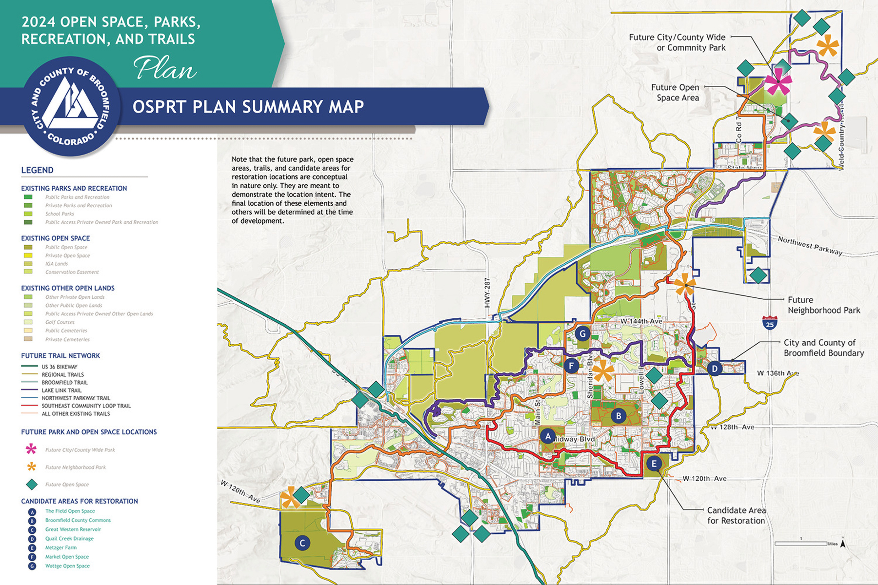
The Open Space, Parks, Recreation and Trails (OSPRT) Plan is a 20-year policy document intended to serve as a roadmap for Broomfield staff, elected officials, advisory committees, and the community to guide decisions about open space, parks, recreation, and trails. The goal of the Plan is to carry Broomfield’s vision of the community into the future and promote a strong sense of unity, pride, and identity. It includes an analysis of Broomfield’s current and future needs for open space, parks, recreation, and trails facilities; it outlines specific implementation strategies that will assist in achieving the community’s goals to acquire additional open lands and trails, preserve natural resources, and enhance existing spaces and facilities. On February 29, 2024, the City and County of Broomfield City Council unanimously approved the Plan.

Read the approved Broomfield OSPRT Plan.

BACK TO PROJECTS


CLIENT

City + County of Broomfield

LOCATION

Broomfield, Colorado

DESIGN SERVICES

Planning + Public Engagement
BACK TO PROJECTS
Achieving 40% Open Lands

The Plan aims to designate 40% of Broomfield’s planning area as open lands, which includes public and private open spaces, parks, and other open lands. Broomfield has a long history of embracing its natural environment, with over 35 years of efforts to acquire and maintain open lands.

Currently, Broomfield has 8,607 acres of open lands—about 36% of the planning area. To meet the 40% goal, an additional 759 acres are needed after accounting for pending and approved public land dedications. Open lands play a crucial role in conserving resources, providing recreational opportunities, and enhancing the community’s walkability and quality of life.

Project photo
Project photo
Project photo
Future Open Space Areas

Open space areas will provide for:

  • The protection of valuable natural resources
  • Opportunities for residents to enjoy nature
  • The conservation of wildlife habitat
  • Passive recreation
  • A well-connected trail network
  • Residents’ physical and mental well-being

Locations in the community where open space conservation is of particular interest include the northern area of Broomfield, US 36, and SH 128 corridors—areas that will augment existing open space, and several infill areas in the existing developed areas of Broomfield. Preserving natural resources such as Little Dry Creek and Preble Creek also helped identify future open space areas.

Project photo
Project photo
Community Engagement

Community engagement results indicate that more open space and park lands are desired.

The goal of the community outreach efforts was to better understand the unique wants and needs of the community to represent the diverse perspectives of Broomfield residents within the Plan, and we used this community input and feedback to inform the technical analysis. Outreach efforts included:

  • Community survey (819 responses)
  • Focus groups (6 with different stakeholder groups)
  • Open house “pop-up” events (18)
  • Additional outreach efforts (newsletters, networking with community partners, etc.)
Project photo
Project photo
Project photo
BACK TO PROJECTS